The cold air stays ahead of winter precipitation for a WVLT First Alert Weather Day Sunday
Courtesy / WVLT News

The cold air stays ahead of winter precipitation for a WVLT First Alert Weather Day Sunday

KNOXVILLE, Tenn. (WVLT) – The forecast for the next 48 hours is fluid and should be watched closely. Any variation of temperatures and moisture into each elevation change can mean a difference in what you see.

Join us on the WVLT First Alert Weather app for iPhone or Android to stay informed. We share custom videos, and you can receive our messages on the latest conditions and forecasts at home.

WHAT TO EXPECT

First off, Saturday is going to be a calm day. If you still need to do any pipe protection or make that warm spot for outside pets, now is the time to do that. It’s sunny, but cold Saturday afternoon with temperatures staying in the mid to upper 30s.

The winds are light, but there is still a relative wind chill. Once that sun sets, we’re headed right back to the 20s overnight.

Sunday starts off cloudy with temperatures near 24.

LOOKING AHEAD

Sunday morning around 7 a.m. is when we’ll need to start checking in on-air and the WVLT First Alert Weather App. The moisture starts to move into the plateau counties and into the valley. It’s the morning hours that we will see a mix of freezing rain, sleet and snow. Once again, that can change drastically depending on where you are and where you are headed.

The WVLT First Alert Weather Day is in effect on Sunday for the potential for frozen roads, bridges and overpasses and powerlines that could come down. A tenth of quart of an inch of ice is possible.
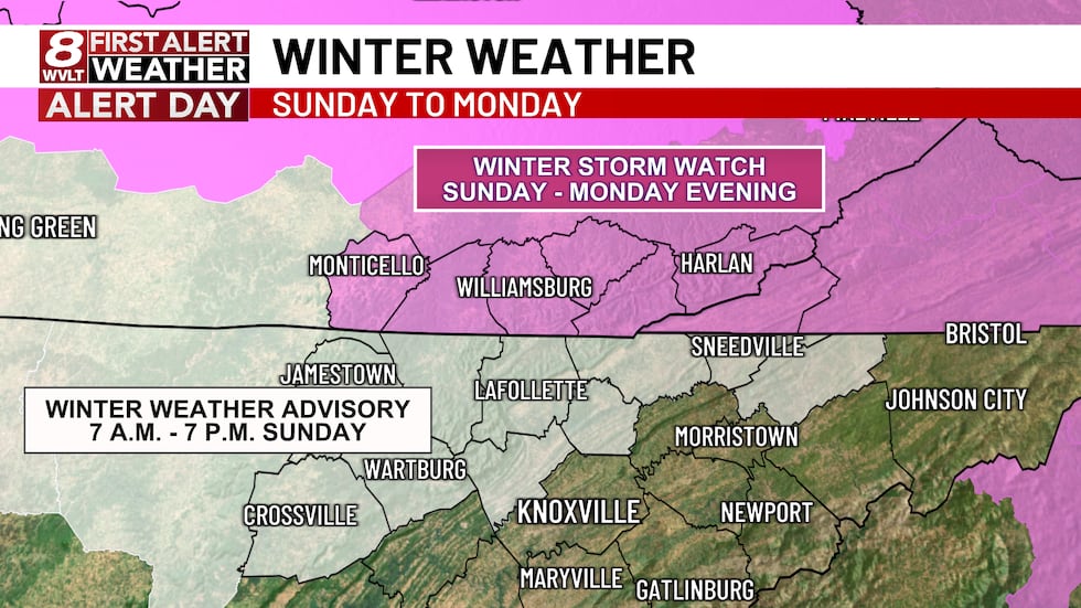
Winter Storm Watch is in effect for SE Kentucky while  a Winter Weather Advisory in effect for...
Winter Storm Watch is in effect for SE Kentucky while a Winter Weather Advisory in effect for Tennessee.(WVLT)
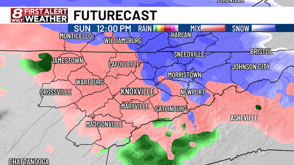
Sunday at noon will be the height of the event on Sunday with snow and freezing rain across...
Sunday at noon will be the height of the event on Sunday with snow and freezing rain across the area.(WVLT)

Eventually, buy the afternoon, this is a transition to all rain, but for temperatures fall back below freezing on Monday for a transition back to snow.

Down the road, Wednesday and Thursday is clear of the precipitation, but we are below freezing for an extended period and that’s the reason for a WVLT First Alert Weather Day once again.
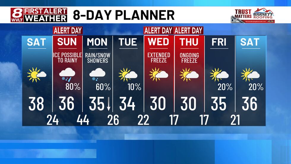
Two sets of WVLT First Alert Weather Days in the 8-Day Planning Forecast.
Two sets of WVLT First Alert Weather Days in the 8-Day Planning Forecast.(WVLT)

Country News

Weather

  • Forecast
  • Currents
  • Planner

Country News

The cold air stays ahead of winter precipitation for a WVLT First Alert Weather Day Sunday
Courtesy / WVLT News

The cold air stays ahead of winter precipitation for a WVLT First Alert Weather Day Sunday

KNOXVILLE, Tenn. (WVLT) – The forecast for the next 48 hours is fluid and should be watched closely. Any variation of temperatures and moisture into each elevation change can mean a difference in what you see.

Join us on the WVLT First Alert Weather app for iPhone or Android to stay informed. We share custom videos, and you can receive our messages on the latest conditions and forecasts at home.

WHAT TO EXPECT

First off, Saturday is going to be a calm day. If you still need to do any pipe protection or make that warm spot for outside pets, now is the time to do that. It’s sunny, but cold Saturday afternoon with temperatures staying in the mid to upper 30s.

The winds are light, but there is still a relative wind chill. Once that sun sets, we’re headed right back to the 20s overnight.

Sunday starts off cloudy with temperatures near 24.

LOOKING AHEAD

Sunday morning around 7 a.m. is when we’ll need to start checking in on-air and the WVLT First Alert Weather App. The moisture starts to move into the plateau counties and into the valley. It’s the morning hours that we will see a mix of freezing rain, sleet and snow. Once again, that can change drastically depending on where you are and where you are headed.

The WVLT First Alert Weather Day is in effect on Sunday for the potential for frozen roads, bridges and overpasses and powerlines that could come down. A tenth of quart of an inch of ice is possible.

Winter Storm Watch is in effect for SE Kentucky while  a Winter Weather Advisory in effect for...
Winter Storm Watch is in effect for SE Kentucky while a Winter Weather Advisory in effect for Tennessee.(WVLT)
Sunday at noon will be the height of the event on Sunday with snow and freezing rain across...
Sunday at noon will be the height of the event on Sunday with snow and freezing rain across the area.(WVLT)

Eventually, buy the afternoon, this is a transition to all rain, but for temperatures fall back below freezing on Monday for a transition back to snow.

Down the road, Wednesday and Thursday is clear of the precipitation, but we are below freezing for an extended period and that’s the reason for a WVLT First Alert Weather Day once again.

Two sets of WVLT First Alert Weather Days in the 8-Day Planning Forecast.
Two sets of WVLT First Alert Weather Days in the 8-Day Planning Forecast.(WVLT)